Conejo Open Space Foundation
  • About Us
    • Our Story…
      • Our Story
      • Board of Directors
      • Accomplishments
    • History…
      • History of the Conejo Open Space
      • Historic Conejo Open Space Promotional Videos
    • Connect With Us
    • Links to Our Friends
    • What are these: COSCA, COSTAC, COSF, CRPD…
    • Privacy Policy as of 2019-06-04
  • Support Us!
    • Overview
    • Volunteer
    • Make a Donation
    • More Ways To Give
  • Get Involved
    • Open Space Programs
    • Event Signup
    • Volunteer!
    • Conejo Open Space Challenge 2025: March 1 to May 31
    • Speaker Series
    • Native Plantpalooza & Eco Fest for 2025
    • Trail Building and Restoration
    • Trails Education Days for 4th Graders
      • Video Overview
      • Recent Updates for Trails Education Days
      • Trails Education Days Videos
    • “Four Seasons” photo contest
      • Sign up for notifications!
    • Scholarships for Environmental Studies
      • How to Apply
      • Scholarships News
  • Volunteering
    • Volunteering Overview
    • Apply to Volunteer
    • Volunteer Report Forms
      • Adopt-A-Trail Report Form
      • Bike Bell Report Form
      • Trail Ambassadors Report
      • Trail Watch Report
      • Log your Trail Work Events
    • Trail Work Notification Signup
    • COSCA Volunteer Manual
  • News
    • Latest News
    • Current Newsletter
    • Newsletter Archive
    • Sign up for our Newsletter!
    • Press Releases
    • Get COSF news on your phone via RSS
  • Explore Open Spaces
    • Open Space Trails and Maps
      • Map Overview
      • Compact PDF Trail Route Guides
      • Conejo Canyons Open Space (Western Plateau)
      • Dos Vientos and Rancho Potrero Open Spaces
      • Lang Ranch, Woodridge and Oakbrook Regional Park
      • Los Robles Open Space area
      • Wildwood Park
      • Other Trails including North Ranch
      • List of Maps
    • Things to do and see
      • Open Space Activities
      • Native Plants
      • Non-Native Plants
      • Wildlife
      • Flora and Fauna Videos
    • Be Prepared
    • Rules of the Trails

Steve Clark

_Special Announcement Conejo OS Challenge Social Media ONLY

It’s New Map Monday: Hidden Meadow and Little Sandstone Trails in Oakbrook Open Space

Highlights Little Sandstone Trail passes through what could be some of the most beautiful sandstone rock formations in the county The “Mini Tripeaks” on Little Sandstone Trail is a great place to explore the rock formations, and to stop for a snack or lunch Hidden Meadow Trail is really fun Read more

By Steve Clark, 1 hour01/05/2026 ago
_Special Announcement Social Media ONLY

It’s New Map Monday: Lynnmere, the Whole Enchilada, in Wildwood

Highlights This moderately strenuous route covers the entire trail and also Thistle Trail for a shortcut to get back to the beginning. The south leg traverses a ridgeline that is high enough to not only overlook the neighborhoods immediately to the south, but also the farther away neighborhoods of Wildwood. Read more

By Steve Clark, 1 week12/29/2025 ago
_Special Announcement Newsletter

2025 Winter COSF Newsletter

The winter edition of the Conejo Open Space Foundation newsletter has been posted. In this edition… Plantpalooza summary : “Raptors in Peril” recording ready for viewing : Newest COSCA Ranger Brittany Schiefer : Spotlight on Brian Stark, COSCA Administrator : High school scholarship announcement : Open Space Appreciation Hike schedule Read more

By Steve Clark, 1 week12/28/2025 ago
_Special Announcement Conejo OS Challenge Social Media ONLY

It’s New Map Monday: Oakbrook Vista & Hidden Meadow Trails

Highlights  Oakbrook Vista Trail quickly gains elevation to give a good view over Oakbrook Regional Park and Lang Ranch Open Space to the north. You’ll get a great view of Albertson Motorway as it winds it’s way up the hills. Hidden Meadow Trail is really fun on a mountain bike Read more

By Steve Clark, 2 weeks12/22/2025 ago
_Special Announcement Conejo OS Challenge Social Media ONLY

It’s New Map Monday: Brookview Loop in Los Robles East

Highlights Brookview Trail runs mostly along a ridgeline so you get great views to the south over Lake Sherwood and north over Thousand Oaks. Brookview and White Horse Canyon Trails are quite remote and rugged, so they are great for getting away from the crowds. Brookview Trail is a segment Read more

By Steve Clark, 3 weeks12/15/2025 ago
_Special Announcement Social Media ONLY

It’s New Map Monday: Oakbrook Vista & Little Sandstone Trails

Highlights Oakbrook Vista Trail quickly gains elevation to give a good view over Oakbrook Regional Park and Lang Ranch Open Space to the north. You’ll get a great view of Albertson Motorway as it winds it’s way up the hills. The very rugged Little Sandstone Trail passes through what could Read more

By Steve Clark, 4 weeks12/08/2025 ago
_Special Announcement Conejo OS Challenge Social Media ONLY

It’s New Map Monday: Vista Del Mar Loop in Dos Vientos

Highlights This route is 4.9 miles long with about 800′ of ascent. The Twin Ponds, roughly half way along Vista Del Mar Trail. If there was a substantial amount of rain the preceding winter, there will be waterfowl in the ponds. The view is constantly changing on these hilly trails, Read more

By Steve Clark, 1 month12/01/2025 ago
_Special Announcement Social Media ONLY

It’s New Map Monday: Oakbrook Vista Trail

Highlights This short out-and-back hike quickly gains elevation to give a good view over Oakbrook Regional Park and Lang Ranch Open Space to the north. You’ll get a great view of Albertson Motorway as it winds it’s way up the hills. In spring, the trail is lined with blooming purple Read more

By Steve Clark, 1 month11/24/2025 ago
_Special Announcement Trailwork
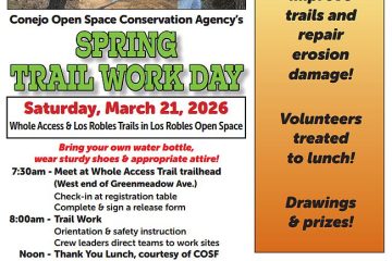
CANCELED due to the Weather: November 22 Trail Work; Photos from September’s work

CANCELED due to the weather: November 22 Trail Work. The following text is from the original announcement. Join the COSCA rangers and other enthusiastic volunteers on November 22  to help fix up the Park View Trail above Dos Vientos Community Park! If you’re looking for for some ways to get Read more

By Steve Clark, 2 months11/19/2025 ago
_Special Announcement Social Media ONLY

It’s New Map Monday: Reino Road to Twin Ponds in Dos Vientos

Highlights This route is 8.0 miles long with about 1300′ of elevation gain. There will be waterfowl in the Twin Ponds if there was a enough rain during the preceding winter to keep the ponds from drying up. The view is constantly changing on these hilly trails, overlooking Dos Vientos Read more

By Steve Clark, 2 months11/17/2025 ago

Posts pagination

1 2 … 36 Next

Hestia | Developed by ThemeIsle